Expanding your logistics network is a high-stakes decision—one that can determine whether your business thrives in new markets or struggles under rising costs and service delays. That’s why companies planning distribution centers, manufacturing plants, or retail outlets turn to the Center of Gravity (CoG) method, a strategic approach for solving facility location problems from scratch.
Whether you’re entering unfamiliar territory or overhauling your current supply chain, this method offers a data-driven path to operational efficiency. In this blog post, we explore how the center of gravity method works, where it’s used, and how anyLogistix enhances its power with advanced capabilities, including road network integration.
Contents:
- The Center of Gravity (CoG) method in the supply chain
- Real-world use cases: where CoG makes a difference
- The theory behind the CoG method
- The CoG method in anyLogistix
- Realistic CoG with road network integration
- Build smarter from the start
The Center of Gravity method in the supply chain
When expanding into new markets, redesigning logistics networks, or planning new facilities, businesses often face a critical question: Where should we locate our operations to minimize costs and maximize service quality? This is where the Center of Gravity method, also known as Greenfield Analysis (GFA), comes in. It’s a powerful strategic tool designed to answer exactly that.
From global retailers to national healthcare systems, CoG is used across industries to build data-driven, future-ready supply chains. Let’s explore what CoG is, how it works, and how anyLogistix takes it to the next level by incorporating real-world road networks.
Real-world use cases: where CoG makes a difference
The center of gravity method is most commonly used in situations where a business is either entering new territory or rethinking its existing network from scratch. It helps determine the best locations for warehouses, factories, stores, or service hubs—based on demand, geography, and cost.
Here are just a few examples of how CoG has been applied across industries:
- Distribution network design from scratch: Manufacturers or e-commerce platforms use CoG to determine the optimal number and placement of warehouses to serve customers efficiently. By following a few key steps, businesses can leverage CoG to design a well-structured logistics network that maximizes efficiency and minimizes costs. To ensure the product stays within the required temperature range, including the last-mile delivery, until the product reaches the end user.
- Manufacturing facility location: CoG considers proximity to suppliers, customer demand centers, and logistics costs to suggest optimal sites for production plants. Learn how a German building materials producer used CoG to solve a facility location problem.
- Logistics network optimization: Improving logistics by identifying and removing inefficient distribution centers and warehouses while strategically locating new ones in high-potential cities or areas. Discover how a food manufacturer designed a distribution network with CoG.
- Cold chain facility siting: In industries that require strict temperature control, CoG helps identify where to place temperature-controlled facilities to minimize spoilage and meet service requirements. Find out how to optimize a cold supply chain to cut costs and reduce risks.
- Healthcare supply chain optimization: Governments and nongovernmental organizations use CoG to determine where to locate vaccine distribution centers or emergency response hubs to ensure timely access in all regions. Learn how researchers used CoG to solve the vaccine outreach problem in Bali during COVID-19.
The theory behind the Center of Gravity method
At its core, the center of gravity method is a classic facility location problem. The "center of gravity" metaphorically refers to the ideal location for a facility that minimizes transportation costs and distances to all demand points.
It assumes that each demand point "pulls" on the facility with a force proportional to its volume (demand), and the goal is to find the balanced point: the location that best serves all points while minimizing total travel effort.
Key elements of the theoretical foundation of CoG include:
- Model inputs: These typically include customer locations (geographic coordinates), demand volumes, transportation costs or distance metrics, and optional constraints such as the number of facilities.
- Optimization techniques: Depending on the model, center-of-gravity algorithms, clustering methods like k-means, or mixed integer programming are used to solve the facility location problem.
- Distance measurement: Basic models often use Euclidean distances (straight-line), while more advanced analyses rely on real road network distances or actual travel time.
- Outputs: A completed CoG delivers optimal facility locations, customer-to-facility assignments, and comprehensive reports on logistics cost, distance, and service levels.
The Center of Gravity method in anyLogistix
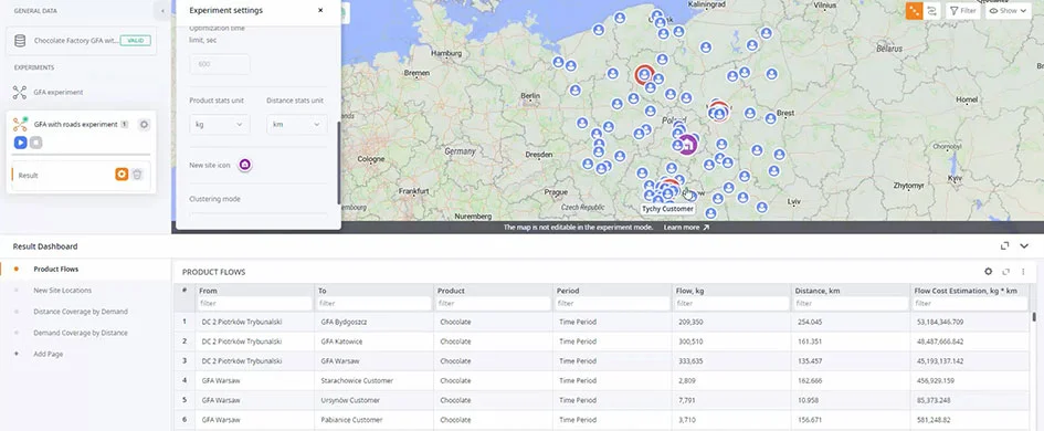
anyLogistix provides a dedicated center of gravity method tool, known as greenfield analysis (GFA), that makes it easy to perform such studies with real-world data and solve facility location problems. Users can define customer demand points, upload geographic coordinates, set optimization criteria (such as minimizing transport cost), and specify how many facilities they plan to open.
The center of gravity method in anyLogistix
The platform’s intuitive interface and integration with geospatial data allow analysts to quickly visualize the results on a map. The model returns the optimal coordinates for new facilities and assigns each customer to the nearest or most cost-effective site. This helps decision-makers understand not just where to locate operations, but also how those decisions affect transportation efficiency and customer coverage.
For businesses comparing multiple network scenarios—such as different numbers of distribution centers or expansion in different regions—anyLogistix allows you to run parallel GFA studies and evaluate them side-by-side using built-in performance dashboards.
The power of roads: realistic CoG with road network integration
While traditional CoG uses straight-line distances, this often doesn’t reflect real-world logistics challenges. Roads aren’t straight, traffic exists, and terrain matters. That’s why CoG or greenfield analysis with roads in anyLogistix is such a game-changer.
When road network data is incorporated into the analysis, the model solves facility location problems based on actual travel distances or times. This makes the suggested facility locations more realistic and actionable. For example, two cities might appear equally close on a map, but when factoring in road access and transport times, one may clearly outperform the other.
Using road-based CoG, you can more accurately predict:
- Actual delivery times to customers.
- Transportation costs based on routes and accessibility.
- Service levels in rural or urban areas with varying road infrastructure.
anyLogistix supports importing road distance matrices and can integrate with GIS tools or external APIs that provide routing data. This enhancement is especially valuable for industries like retail, cold chain, or healthcare, where delivery time is critical and infrastructure variability must be considered.
CoG (left) and CoG with roads (right) experiments in anyLogistix (click to enlarge)
The center of gravity method video demonstration in anyLogistix
Build smarter from the start
The center of gravity method is more than just a planning tool—it's a strategic compass for long-term supply chain growth. Whether you're setting up a new distribution network, entering an emerging market, or redesigning an aging logistics system, CoG provides the clarity needed to solve your facility location problem with confidence.
And when combined with road network data in anyLogistix, it becomes even more powerful—transforming abstract coordinates into smart, feasible, and high-performing logistics strategies.
Ready to map out your optimal supply chain from the ground up? Try center of gravity in anyLogistix today.
download


 and CoG with roads (right) experiments in anyLogistix")